|
Size: 90
Comment:
|
Size: 4529
Comment:
|
| Deletions are marked like this. | Additions are marked like this. |
| Line 2: | Line 2: |
[[attachment:astringent_river.png|{{attachment:astringent_river.png||width=400}}]] ==== Astringent River ==== A river in the Far North of the Earth Kingdom, named for its association with the production of alum and the trade in the same. It opens into the Third Sister Bay at the town of Seshi. It is an important route for general trade with the interior as well. It mostly lies within the East Shuizu State, but the westernmost headwaters are in the West Shuizu State. ==== Seshi ==== [[Avatar/Seshi|Seshi]] is a port town in the Third Sister Bay, West of [[Avatar/Beigang|Beigang]], at the mouth of the Astringent River. It has several thousand inhabitants. ==== Oystercrab Creek ==== A tributary of the Astringent River, mostly running through forest. It is navigable for about fifteen kilometers upstream of the confluence, before it becomes too shallow. There are many minor hamlets along the creek, mostly populated by Beituzhu aboriginals. Nomadic Shuizu traders are often seen. Anadromos oystercrabs can be collected in some abundance during the late spring of approximately every fifth year, when they move inland to spawn. ==== Guicun ==== A Shuizu village under indigenous governance. Its population is about 900, of mixed Shuizu and Beituzhu ethnicity. There are a few families with Zhongzu ancestry, descended from settlers who assimilated. It is supported by fishing, forest products, and some horticultural activity, and has a minor market. ==== Lushi ==== A Zhongzu settlement, with a population of about 2800 people. It has a good stone wall, attributed to founding father Lu Zhuqiang who came from the Five Grains Province. There are also aboriginals living in the mixed population; none of the major families are exclusively Zhongzu. It is governed by a Rank 8 Official of the Hao Ting. There is an important market, and an overland connection to the Ami Town Road and Fencun. The village was built around the site of an old Beituzhu temple, which had supposedly been abandoned prior to the coming of the settlers, the sanctum of the temple was preserved (having been thought to be the tomb of some ancient worthy.) ==== Sandy Creek ==== A tributary of the Astringent River. It is shallow and wide, and when the flow is at a low ebb, it is not navigable even as far as Fencun. The sand is coarse and angular, and considered good for building but poor for glassmaking, as it yields opaque glass. It runs mostly through the boreal forest. ==== Fencun ==== A village at the fork of the Sandy Creek and a minor tributary of tenuous navigability (locally called Yao's Creek.) It is mostly a Beituzhu village. About 500 people live there, with the population doubling on market days as the hunters and farmers from surrounding hamlets come to trade. There are a few inns serving travelers on the Ami Town Road. ==== Ami Town Road ==== This road was constructed during the Ri Dynasty to connect Ami Town with the many isolated aboriginal hamlets in the interior. Later, during the Hao Ting renaissance, it was extended to connect Fencun to Lushi, avoiding the seasonal availability issues of the Sandy Creek. These days, the road has fallen into poor repair south of the Ba Sing Se Highway (with which it intersects far to the North of this map.) However, it is usually passable when the weather is good, on foot or ostrich-horse, but not by cart. The extension between Fencun and Lushi is in good repair. ==== Vernal Creek ==== Navigable only during the spring snowmelt, this tributary of the Astringent River is a seasonal trade corridor for many aboriginal (Beituzhu) hamlets sustaining themselves with settled horticulture and hunting. ==== Baicun ==== ||Old Yu's Creek|| || ||Shuicun|| || ||Ping Creek|| || ==== Niantucun ==== This village is a hub of the alum trade, and along with Shuicun it is a site for processing and refinement of alunite into alum products, although many mining communities perform their own calcination near their mines. There is a minor market here and good docks. ||Jellytrout Creek|| || ||Suicun|| || ||Water Mountain|| || ||Northern Barrier Mountains|| || ||Erercun|| || ||Rain Peak|| || ||Brown Creek|| || ||Guicun|| || ||Tepid Lake|| || ||Xuecun|| || ||Manbao Lake|| || ||Manbao|| || ||Chief Mountains|| || ||Chief Peak|| || ||Little Qin Pass|| || ||Ba Sing Se Highway|| || ||Shankocun|| || |
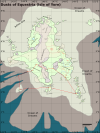
This is a brief overview of the Astringent River watershed and some surrounding regions.

Astringent River
A river in the Far North of the Earth Kingdom, named for its association with the production of alum and the trade in the same. It opens into the Third Sister Bay at the town of Seshi. It is an important route for general trade with the interior as well. It mostly lies within the East Shuizu State, but the westernmost headwaters are in the West Shuizu State.
Seshi
Seshi is a port town in the Third Sister Bay, West of Beigang, at the mouth of the Astringent River. It has several thousand inhabitants.
Oystercrab Creek
A tributary of the Astringent River, mostly running through forest. It is navigable for about fifteen kilometers upstream of the confluence, before it becomes too shallow. There are many minor hamlets along the creek, mostly populated by Beituzhu aboriginals. Nomadic Shuizu traders are often seen. Anadromos oystercrabs can be collected in some abundance during the late spring of approximately every fifth year, when they move inland to spawn.
Guicun
A Shuizu village under indigenous governance. Its population is about 900, of mixed Shuizu and Beituzhu ethnicity. There are a few families with Zhongzu ancestry, descended from settlers who assimilated. It is supported by fishing, forest products, and some horticultural activity, and has a minor market.
Lushi
A Zhongzu settlement, with a population of about 2800 people. It has a good stone wall, attributed to founding father Lu Zhuqiang who came from the Five Grains Province. There are also aboriginals living in the mixed population; none of the major families are exclusively Zhongzu. It is governed by a Rank 8 Official of the Hao Ting. There is an important market, and an overland connection to the Ami Town Road and Fencun. The village was built around the site of an old Beituzhu temple, which had supposedly been abandoned prior to the coming of the settlers, the sanctum of the temple was preserved (having been thought to be the tomb of some ancient worthy.)
Sandy Creek
A tributary of the Astringent River. It is shallow and wide, and when the flow is at a low ebb, it is not navigable even as far as Fencun. The sand is coarse and angular, and considered good for building but poor for glassmaking, as it yields opaque glass. It runs mostly through the boreal forest.
Fencun
A village at the fork of the Sandy Creek and a minor tributary of tenuous navigability (locally called Yao's Creek.) It is mostly a Beituzhu village. About 500 people live there, with the population doubling on market days as the hunters and farmers from surrounding hamlets come to trade. There are a few inns serving travelers on the Ami Town Road.
Ami Town Road
This road was constructed during the Ri Dynasty to connect Ami Town with the many isolated aboriginal hamlets in the interior. Later, during the Hao Ting renaissance, it was extended to connect Fencun to Lushi, avoiding the seasonal availability issues of the Sandy Creek. These days, the road has fallen into poor repair south of the Ba Sing Se Highway (with which it intersects far to the North of this map.) However, it is usually passable when the weather is good, on foot or ostrich-horse, but not by cart. The extension between Fencun and Lushi is in good repair.
Vernal Creek
Navigable only during the spring snowmelt, this tributary of the Astringent River is a seasonal trade corridor for many aboriginal (Beituzhu) hamlets sustaining themselves with settled horticulture and hunting.
Baicun
Old Yu's Creek |
|
Shuicun |
|
Ping Creek |
|
Niantucun
This village is a hub of the alum trade, and along with Shuicun it is a site for processing and refinement of alunite into alum products, although many mining communities perform their own calcination near their mines. There is a minor market here and good docks.
Jellytrout Creek |
|
Suicun |
|
Water Mountain |
|
Northern Barrier Mountains |
|
Erercun |
|
Rain Peak |
|
Brown Creek |
|
Guicun |
|
Tepid Lake |
|
Xuecun |
|
Manbao Lake |
|
Manbao |
|
Chief Mountains |
|
Chief Peak |
|
Little Qin Pass |
|
Ba Sing Se Highway |
|
Shankocun |
|