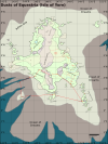
This is a brief overview of the Astringent River watershed and some surrounding regions.

Astringent River
A river in the Far North of the Earth Kingdom, named for its association with the production of alum and the trade in the same. It opens into the Third Sister Bay at the town of Seshi. It is an important route for general trade with the interior as well. It mostly lies within the East Shuizu State, but the westernmost headwaters are in the West Shuizu State.
Seshi
Seshi is a port town in the Third Sister Bay, West of Beigang, at the mouth of the Astringent River. It has about 7200 inhabitants.
Oystercrab Creek
A tributary of the Astringent River, mostly running through forest. It is navigable for about fifteen kilometers upstream of the confluence, before it becomes too shallow. There are many minor hamlets along the creek, mostly populated by Beituzhu aboriginals. Nomadic Shuizu traders are often seen. Anadromos oystercrabs can be collected in some abundance during the late spring of approximately every fifth year, when they move inland to spawn.
Guicun
A Shuizu village under indigenous governance. Its population is about 900, of mixed Shuizu and Beituzhu ethnicity. There are a few families with Zhongzu ancestry, descended from settlers who assimilated. It is supported by fishing, forest products, and some horticultural activity, and has a minor market.
Lushi
A Zhongzu settlement, with a population of about 2800 people. It has a good stone wall, attributed to founding father Lu Zhuqiang who came from the Five Grains Province. There are also aboriginals living in the mixed population; none of the major families are exclusively Zhongzu. It is governed by a Rank 8 Official of the Hao Ting. There is an important market, and an overland connection to the Ami Town Road and Fencun. The village was built around the site of an old Beituzhu temple, which had supposedly been abandoned prior to the coming of the settlers, the sanctum of the temple was preserved (having been thought to be the tomb of some ancient worthy.)
Sandy Creek
A tributary of the Astringent River. It is shallow and wide, and when the flow is at a low ebb, it is not navigable even as far as Fencun. The sand is coarse and angular, and considered good for building but poor for glassmaking, as it yields opaque glass. It runs mostly through the boreal forest.
Fencun
A village at the fork of the Sandy Creek and a minor tributary of tenuous navigability (locally called Yao's Creek.) It is mostly a Beituzhu village. About 500 people live there, with the population doubling on market days as the hunters and farmers from surrounding hamlets come to trade. There are a few inns serving travelers on the Ami Town Road.
Ami Town Road
This road was constructed during the Ri Dynasty to connect Ami Town with the many isolated aboriginal hamlets in the interior. Later, during the Hao Ting renaissance, it was extended to connect Fencun to Lushi, avoiding the seasonal availability issues of the Sandy Creek. These days, the road has fallen into poor repair south of the Ba Sing Se Highway (with which it intersects far to the North of this map.) However, it is usually passable when the weather is good, on foot or ostrich-horse, but not by cart. The extension between Fencun and Lushi is in good repair.
Vernal Creek
Navigable only during the spring snowmelt, this tributary of the Astringent River is a seasonal trade corridor for many aboriginal (Beituzhu) hamlets sustaining themselves with settled horticulture and hunting.
Baicun
A village of mainly Beituzhu, with a Ganjinese trading post. Near Baicun is a wide, shallow and sandy section of the astringent river from the confluence with the Vernal Creek to the confluence with Old Yu's Creek; this section is dredged by benders employed by the indigenous elders of Baicun, who have a toll chain across the river to force people to pay for it. The population is about 700.
Old Yu's Creek
A fertile region which was settled by Zhongzu settlers centuries ago. They mixed freely with the indigenous earthbending aboriginals as well as the Suizu, and have something of a hybrid culture centered around hunting, herding and horticulture. There are no large settlements, but many small hamlets along the tributaries of the creek, most of which are seasonally navigable.
Shuicun
A large village of about 3900 inhabitants, mostly settled Shuizu (tributary water tribes) with Beituzhu and Zhongzu admixture. It is a center of the building of small boats. It is governed by a Shuizu headman and council of elders. Alum is produced by calcination, and there are two smelters. There is some agriculture, of short-season buckwheat, and fairly extensive cleared land because of timber harvesting. It is also developed as a center of carpentry, and there is a fair amount of tanning and leatherworking activity, mostly in the Shuizu tradition; traditional light summer dwellings, suitable for carrying on small boats, are made here for the use of Shuizu semi-nomads. In the summer, there is a notable Shuizu festival to the Moon Spirit.
Ping Creek
Known for its highly favorable navigability, though it runs through deep channels as it approaches the foothills. There are many artisanal mines in the hills, and placer mining throughout. It runs through forest for much of its course, and there are some Beituzhu hamlets.
Niantucun
This village is a hub of the alum trade, and along with Shuicun it is a site for processing and refinement of alunite into alum products, although many mining communities perform their own calcination near their mines. There is a minor market here and good docks. The population is about 1800, of Beituzhu, Shuizu and Yonggan, all with Zhongzu admixture.
Jellytrout Creek
A long, mostly navigable creek arising in the mountains. There are a variety of hunting and agricultural hamlets in the boreal forest, with mining and mountain settlements in the North.
Suicun
A Shuizu village under indigenous governance. (Not to be confused with Shuicun.) The population is about 1200, and the economy is based on mining and fishing with a little agriculture. Formerly, there was a Ganjinese factory here, but it has been abandoned for a century and the buildings are used by the headman.
Water Mountain
Creatively named in the Common language by Zhongzu settlers, its native name (in an extinct Beituzhu dialect) is Ambamajtu. True to the Common name, it has numerous cold mineral springs. To the tree line, it is covered in coniferous boreal forest.
Northern Barrier Mountains
The Northern Barrier mountains form part of the natural geographic division between the Northern Earth Kingdom and the Central Earth Kingdom, being between the East Shuizu State in the North, and the Five Grains Province of the heartland. The mountains have a developed pass connecting the Ba Sing Se highway and Bear River road; this is also connected overland to Manbao and the Astringent River region, and is important for overland trade. Some peripheral bands of seminomadic Eastern Yonggan inhabit the mountains seasonally, and there are some hardscrabble artisanal mines.
Erercun
Another Shuizu village under indigenous governance, with a native headman. Population is about 800. There are also some Beituzhu and people of mixed ethnic heritage there. A well-known Shuizu canoe-maker family lives there, living in self-imposed exile from Shuicun.
Rain Peak
The highest of the Northern Barrier Mountains. Once rich in minerals, it is nowadays mostly depleted, and honeycombed with badgermole tunnels and abandoned mines. Some hardy miners still work in the area.
Brown Creek
The Brown Creek is so-called for the color its waters sometimes exhibit during unusually rainy periods.
Guicun
A fishing village and minor trading hub, with mostly Beituzhu and Shuizu inhabitants. It is under indigenous governance.
Tepid Lake
A lake which is, among other sources of water, fed by a hot spring. It does not freeze entirely even during the winter, for this reason, and has excellent fishing. Despite this, it does not support any substantial villages, because it is surrounded on all sides by bogs. Besides fishing, peat is also cut there. Shuizu legend says the hot spring is a resting fire spirit. There is a small Shuizu hamlet on the lakeshore, which has buildings supported on pilings.
Xuecun
A mixed aboriginal village, named for the edible wormwood marshgrass of the surrounding swamps. This is a valued ingredient in Beituzhu brewing. It is a market village for the surrounding countryside, and it has docks on a minor tributary of the astringent river, leading to the Tepid Lake. A festival for the propitiation of the malaria-spirit is held in the Springtime, which, it is said, involved a human sacrifice in ancient times; now a humanoid figure stuffed with dried, fragrant herbs is burned instead.
Manbao
A an old town that developed around a fort and trading post. The fort is very ancient, almost two thousand years old, and was constructed by the Tu Dynasty of Earth Kings to trade with - and check the expansion of - the Alarame people (among the predecessors of the Yonggan.) The town is very diverse, with a narrow plurality of Beituzhu, and a fair number of Zhongzu, many of mixed descent. There is a significant Yonggan minority, involved in the metalworking trade and badgermole husbandry.
Manbao is governed by an appointed mayor, a Rank 7 official of the Hao Ting. It has a small garrison of the royal earth army. There is a post office, several inns and bathhouses, and considerable secondary economic activity in metalworking and other crafts, and in support of mining in the nearby mountains. Silver, lead, copper, and zinc smelting are significant, though forbidden within the walls of the city. The population is about 6200.
Manbao Lake
A small lake, containing a proportionately-large island with a hot spring, inn and bathhouse, and a few other residential structures. This is the headwaters of the Astringent River. A bridge crosses the outflowing river, carrying the Ba Sing Se highway. The lake also contains the docks of Manbao. Two tributary creeks flow into the lake from the Chief Mountains; they are not navigable by any boats larger than a canoe, and that only as far as the foothills beginning a few kilometers west and north of Manbao.
Chief Mountains, Chief Peak
A small northern mountain range. For a long time, the Chief Peak represented the Easternmost point of Yonggan territory. It is considered by traditional Eastern Yonggan shamanism to be a numinous site, where the Mountain Spirit Antu ("Sunny [i.e. Southern] side of a mountain") came to Earth and fathered the ancestor of the Yonggan people, Baturu. (To the Western Yonggan, the mountain in the myth was instead Mt. Sun, today in the Yonggan State.) Nonetheless, it is a sacred mountain to all common varieties of Yonggan Shamanism and the State Religion of the Great Ri; a shrine near the summit was grandly restored during the Shenxing reign. It still exists, though as it is no longer supported by the state and supported only by visitors, it is in relatively poor repair.
Little Qin Pass
A pass built, not by Qin the Conqueror (as was the case for most of the other Qin roads, bridges and tunnels in the North) but by another earthbender of that name. It consists of several tunnels connected by valley roads through the Chief Peaks. It predates the Ba Sing Se highway, but was widened and expanded when that road was built.
Ba Sing Se Highway
A road built by the Hao Ting dynasty during their Renaissance after the defeat of Qin the Conqueror and the conclusion of the Earth Kingdom Civil War. At this time, Avatar Kyoshi and the Earth Sages were introducing bracing reforms to the Earth Kingdom government, part of which was increased spending on infrastructure that would provide stronger links between the Central Plains and the other regions. This very long road was one such project. It runs from Ami Town, down to Ba Sing Se via the Five Grains Province.
Shankocun
A village named for its position at the foothills of the chief mountains, on a road to the mountain pass. It is a Zhongzu colony, mainly settled by colonists from the Central Earth Kingdom around the time the Ba Sing Se highway was built.